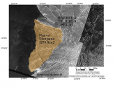
Thanks to images provided by Argentina’s SAOCOM 1A satellite, specialists from the Argentine Antarctic Institute (IAA), dependent on the Ministry of Foreign Affairs, were able to detect the calving of an iceberg in Antarctica and to determine that its size is about 1,270 square kilometres.
The IAA Department of Glaciology has been studying the stability and dynamics of ice shelves in Antarctica for decades, especially in the Antarctic Peninsula region. Access to satellite images provided by different missions of space agencies is essential for the study and monitoring of ice bodies. In those sites that, due to their proximity, are accessible during the summer Antarctic campaigns, sensor installations are made and measurements are carried out to complement the satellite data.
In recent years, Argentina has launched two satellites developed in the country, SAOCOM 1A and SAOCOM 1B of the National Commission for Space Activities (CONAE). “The development of national science and technology has given our country access to more images to expand the satellite database and to be able to track the dynamics of Antarctic glaciers more regularly”, said the Secretary of Malvinas, Antarctica and South Atlantic, Daniel Filmus.
The process and tracking
An ice shelf is formed by a floating mass of ice, which is the continuation in the ocean of glaciers that come from the continent, in this case from Antarctica. Ice flowing from the mountains or from the Antarctic elevations continues its movement, bringing ice to the shelves, pushing them out to the open sea. When the internal forces due to the movement exceed the breakdown point, either because of the tides or because they hit a geographical accident, the ice breaks and a crack appears. This is a natural process for glaciers and therefore also for ice shelves. The cracks widen until a block breaks off and becomes detached. When this occurs in water, this block becomes an iceberg.
In the case of the Brunt Ice Shelf this process, which began at the end of 2019, evolved throughout 2020 creating an iceberg of approximately 1,270 square kilometers. The location of the ice shelves and the distance that separates them from the Antarctic bases can be considerable. The Argentine Belgrano II Base, for example, is located 400 kilometers southwest of the barrier. Much further away are the cities where the research institutions that carry out the tracking and study of these ice bodies are based. For this reason, its evolution is carried out mainly through satellite images.
This shelf, which has lost 1,270 square kilometers, still has other important cracks that have appeared in recent years and that will cause other iceberg calvings in the future. For this reason, the tracking does not end with the calving of this iceberg. As long as it does not suffer the activity of the oceans and stays in low-temperature sea areas, it can remain without melting for many years. However, it is important to analyze these large iceberg detachment processes to improve our understanding of the dynamics of the Antarctic ice shelves.
As far as navigation is concerned, only a few ships sail in this remote southern region. The Argentine logistics and scientific campaign has already accessed this area at the end of last January and will not do so again until next summer, so the next step is to continue tracking the position of the iceberg (and any other icebergs that may detach) to plan and support the sailing of the next Summer Antarctic Campaign. In addition to our logistics ships, those ships that sail in Antarctic waters and request information from Argentine satellites may also benefit from these images as a tool for navigation assistance, which shows the multiple uses of this type of data.


